eachedThe Lions are the two most distinctive peaks seen from downtown Vancouver. The best place to see them from relatively close is the dam on Capilano Lake in the north tip of Capilano River Regional Park. Several trails are leading to the Lions, but none of the paths leads to any of the peaks.
East Lion is in the watershed area, and entrance is forbidden. The West Lion is where many people climb instead. There are several ways up to the peak, but they all require some scrambling, so it’s considered a dangerous and challenging approach here in Canada. Therefore, many hikers finish their ascent on a plateau just at the foot of the West Lion.
The hike is quite long, so if you are less experienced, you may prefer an easier one such as the hike to the Chiefs to test your stamina. Check our guide for other exciting hikes around Vancouver too!
The Lions Hike Hiking Info
Difficulty: Moderate
Options for the starting point: The Lions Trailheads
The nearest place to start hiking to the Lions is in Lions Bay on Sea to Sky Highway. Here you can use either Binkert Trail (shorter) or Unnecessary Mountain trail (longer). I decided to make a loop and go up with the shorter and most popular Binkert Trail and head down to the settlement via Unnecessary Mountain. The alternative approach to the Lions is from Cypress Provincial Park, but this is a significantly longer option.
Lions Bay is a small settlement relatively close to Vancouver. However, with public transit, it still takes almost 2 hours to get there from where we live. The trip requires a few changes in buses. From the downtown of Vancouver, I took a bus that follows the road on the seaside to Horseshoe Bay. That’s a pleasant scenic route, and you can see the big cargo ships mooring from there, and it’s closer than when walking in Stanley Park.
I had to wait for the minibus to Lions Bay for a while, but I was lucky to fit in 90 minutes window to make every change, so I paid only a single transit fare. $2.10 for reaching the trail was a terrific deal. And, even more importantly, I wasn’t dependent on anyone else to get to the trailhead. Unfortunately, Katalin couldn’t join me for the hike, because she was away on Vancouver Island.
Lions Hike Vancouver
[sgpx gpx=”/wp-content/uploads/gpx/lions.gpx”]
Lions Binkert Trail
The Binkert Trail is about 8 km long and climbs 1200 m higher. As I was about to find out that guarantees great views to the Howe Sound from above! I started quite late, at 9, but the trail was empty. I didn’t meet anyone until I was coming down from the West Lion towards the Unnecessary Mountain.
At first, the trail follows an unused logging road. It’s easy to follow and not steep at all. It also means that there are no views as the road leads through the forest. In the forest, there are two points where you must turn from the main, i.e. better visible road. Both of them are marked, but there are no official signs. The existing marks are obvious but pretty small, so if you’re walking with others and are busy talking, you may miss them and end up in the wrong way. Similar signage is there for trails to Harvey Mountain.
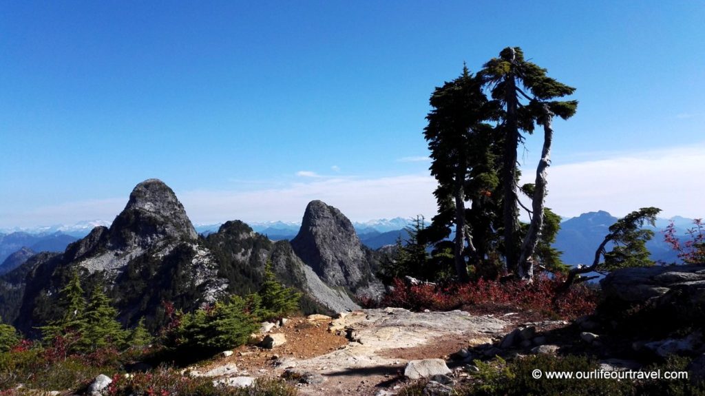
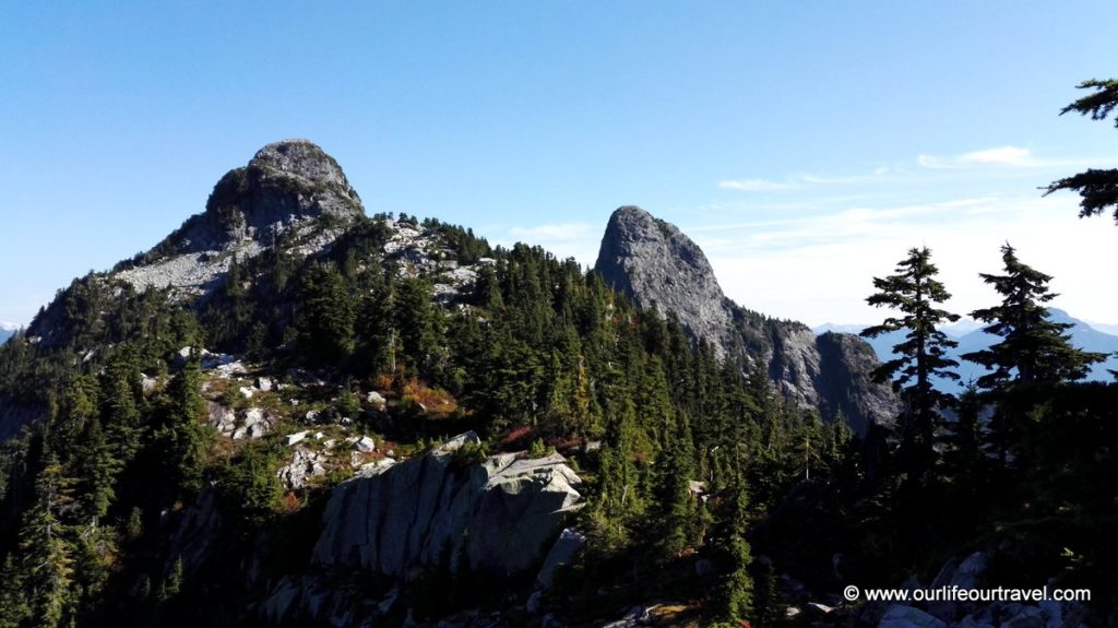
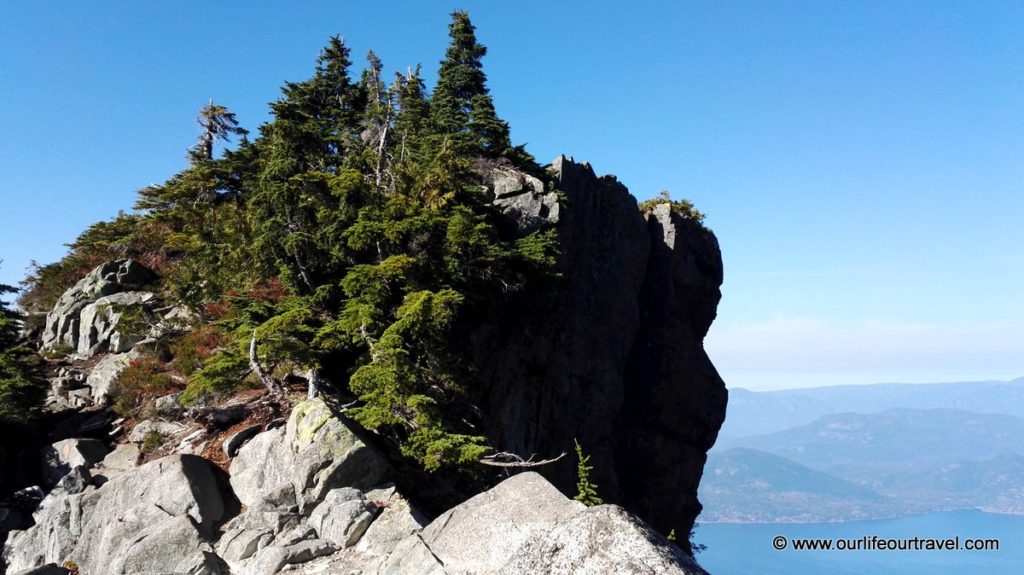
Finally, when the forest finally ends, there are amazing views to the West Lion and Harvey Mountain and Howe Sound. The steep Lion looks magnificent. It’s clear that any mistake climbing the peak might be fatal. I wouldn’t approach it when the rocks are wet. From here, it feels like the plateau before the Lion appeared deceptively close. I still needed some time to reach the junction of my trail with Howe Sound Crest Trail from the direction of Unnecessary Mountain. From there, I could finally see Vancouver in the far distance. It is also the first time when the East Lion is visible. Continuing to the left, I follow the ridge on rocky, two rocky plateaus towards the West Lion. Here I don’t follow the trail as it’s not so clearly marked, and I assume I can follow the ridge. Having the Lion in sight, I suddenly end up on the edge of an overhanging rock with nothing but a few hundreds of meters of air when I planned to put my foot in the next step.
The West Lion
From this point, I can see that the plateau is connected to the Lion only by a narrow path. To reach the trail, I need to descend about 4 meters down on an exposed rope. The feeling of exposure is reduced by a small tree growing in the way of the potential fall. The line is quite worn. Luckily I’m not heavy, so I manage to descend. From there, I can’t spot any marks of the way to the top, so I decide to navigate my own way to the summit.
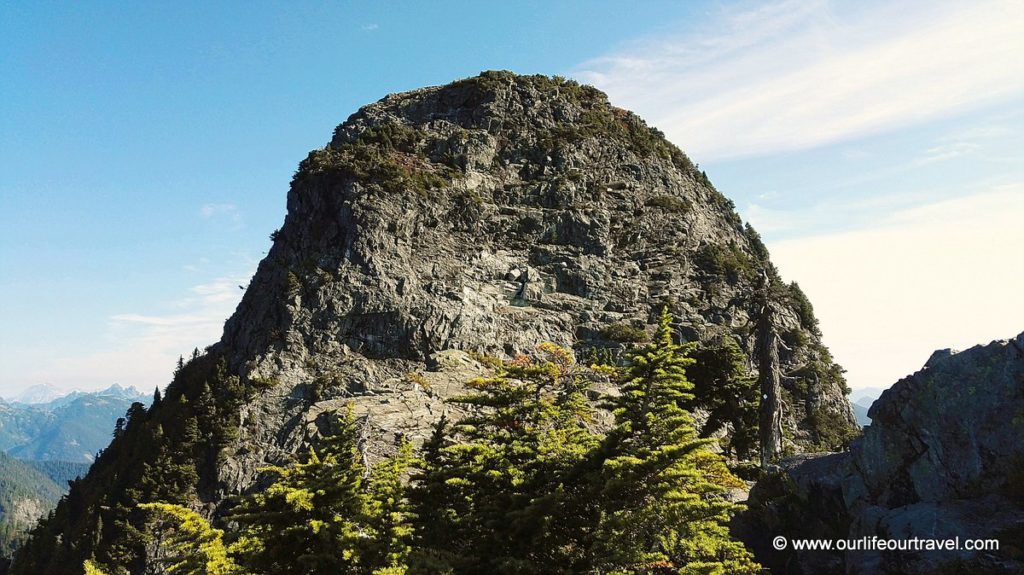
My mistake was not to read the description of the peak approach carefully before. I decided to go up steering as far from exposed parts as possible, but that led me to nowhere. Or more precisely, to an area that wasn’t too exposed, but no points were providing a sure grip and sliding few meters wasn’t an option here as an abyss started there. So I decided to track back to the rope, which I knew is for sure a part of the approach to the peak used by most of the hikers. Unfortunately, from here, I still couldn’t see any obvious signs what path to take, so I decided to give up on the Lion 🙁 I went back to the junction of the trails. Around that point, I met first hikers.
Unnecessary Mountain Trail – Better than the famous Grouse Grind
On the junction, I went straight towards the Unnecessary Mountain. The mountain got its name because it used to be on the trail to Lions, and now it’s unnecessary to climb it to reach the rocky peaks. The views from this part of the trail were still amazing. In the back, there are two Lions and in front, but much below are waters of Howe Sound.
The trail goes next to lovely rocky cliffs before reaching the peaks of the Unnecessary Mountains. The trail is not well marked. The highest peak of the mountain is marked with one small pole with a map of Howe Sound Crest Trail attached to it. The map doesn’t have any adjacent trails. Because of that, finding the path down to Lions Bay wasn’t that easy.
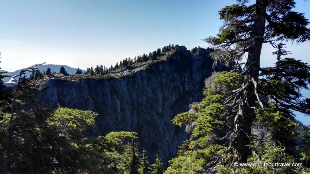
First, I continued too far on the main trail following the rocky cliffs that separated me from the ocean. I knew I couldn’t try to walk down anywhere here. Finally, I turned back to the pole with the map. I assumed that the pole is in the place where the trails meet. That was a reasonable assumption. After a few minutes of looking for a path down, I found a pretty much utterly overgrown way leading towards the ocean. There were some old markings, but only on rocks on the ground, so some of them were difficult to spot between the vegetation. The path was sometimes much more visible, but sometimes the not overgrown paths ended with a cliff, so I had to retrace my steps and take path covered with vegetation.
When the trail reached an old forest, it transformed into a visible path. But on the way down, I had to cross many sections (usually concise) of a younger forest where the path was completely overgrown. Remembering our short walk next to Vladivostok on a similar overgrown path, I was a bit concerned about how many ticks I’ll have on me before I reach Lions Bay.
Also, in some sections, the trail is very steep. Combining in some sections all the steepness, young forest, and fallen trunks of big old trees, the trail becomes challenging. Probably on the way up, it’s like the famous Grouse Grind. The Grouse Grind trail is a popular destination for runners who train on the steep approach. This one is probably better as it has much better views and you can go both up and down. On Grouse Grind, you have to pay for gondola ride down. And the Unnecessary Mountain trail is empty. There were no people on it.
Way back to Vancouver
Luckily I reached the settlement without any ticks. As on the way up, the nearest bus stop is about 1 km away from the trailhead. This time I took the minibus to the Horseshoe Bay Ferry Terminal and changed there to an express bus to downtown Vancouver. That bus goes from Horseshoe Bay on the highway almost to the Lions Gate Bridge, so it’s much faster.